A TIMELINE FOR THE PLANET click for Home page
Boats and Sail
We will almost certainly never know
when humans first got on to the water.
reed
craft Colonising SE Asia Colonising America Colonising the Pacific Sail & Egyptian boats square rig fore-and-aft rig
I’m allowed to speculate in a way the scientists are
generally not. I reckon that it was
probably tens or even hundreds of thousands of years before we are ever likely
to have any hard evidence.
We discuss elsewhere
the notion that our ancestors of, say ½ million years a ago, were a good deal
smarter than they had previously been given credit for. We would never have believed them capable of
making superb throwing spears until some were found. It was one thing to find animal
shoulder-blades with spear holes in them.
To find the spears that made them was something else altogether.
But you never know.
Mud is a wonderful preservative.
One day we may find evidence of simple boats from that far back.
Reed craft
Closer to our time, we have a bit of a mystery.
Craft built from bundles of reeds have been found in 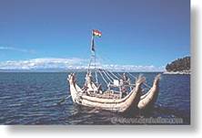 coast
of
coast
of
How is it that such similar vessels are to be found in
places so far apart? Did some mysterious
deity descend, provide seed for the reeds and pass on the technology? There are more prosaic explanations.
Here’s where I either go right out on a limb, or put
two and two together properly for the first time.
First we must remember that 150 million years ago,
Second, a group of scientists believes passionately
that we, or our immediate ancestors, went through a semi-aquatic phase; in
which we survived by spending much of our time in the water. We discuss it briefly here, but there’s more on the Internet under
‘Aquatic Ape Theory’. If there was such
a phase, then it could well have happened just as we moderns were splitting off
from other folk of the period. That
seems the best candidate to me anyway.
It looks to have been somewhere around 200 thousand years ago.
If so then we have fully modern humans, earning their
living swimming and diving in the water.
If ever there was an incentive to invent boats then this was it. And if the only material available was reeds,
then reeds it would have to be.
Eventually conditions improved and we were able to expand
out of our aquatic niche. We spread out
around the world, some of us keeping to the coasts and eventually reaching the
Americas, the Pacific islands and Australia.
Did we remember how to build reed boats throughout
long periods when we didn’t need them, or didn’t have any reeds? Well it seems that illiterate societies often
have specials castes of story tellers, whose role is to pass on ancient myths
and legends – accurately – and to tell them in an exciting and interesting
way. So I see no reason why not. A simpler explanation might be that, if you
want a boat and all you have is reeds, maybe there’s really only one way to do
the job.
Colonising South-East Asia
An article in Science (19.10.07) reckons that
South-East Asia 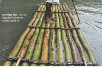 was
colonised using bamboo rafts, large enough to take up to 20 people. The idea is that a viable group would have to
comprise 5-10 women of reproductive age and a similar number of men.
was
colonised using bamboo rafts, large enough to take up to 20 people. The idea is that a viable group would have to
comprise 5-10 women of reproductive age and a similar number of men.
However a lively, even sharp, debate rages over how
far the colonisation was deliberate, and how far it was accidental. The following is my attempt to chart a
middle course.
The map comes from the Science article. It shows the coastline 22 ky ago. This is a bit later than the period we are
interested in. But it shows clearly how
much easier movement was when the sea level was much lower.
The first known colonising voyage was actually carried
out by Homo erectus folk, when they arrived on the 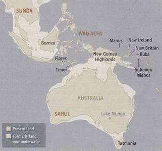 inventing
boats of some kind. The problem is that there’s no other evidence whatsoever of
their having any interest in boats. So
theory B is that a viable group somehow got swept across to
inventing
boats of some kind. The problem is that there’s no other evidence whatsoever of
their having any interest in boats. So
theory B is that a viable group somehow got swept across to
Modern humans were the first to leave any evidence of
having crossed the waters. The dates are
controversial, but a comprehensive article in New Scientist (27.10.07)
suggests 50 ky, for us to have got as far as Australia. How far was the sea
crossing accidental? Opinions differ.
Some scientists point out that the South-East Asian
waters were an excellent training ground for budding seafarers. There was no need for them to have any great
explorations in mind. Not only was the
sea warm, but both the coastal and deep waters provided superb fishing. So all they needed to do was to get better
and more adventurous in their fishing trips.
They could easily have ended up becoming quite serious seafarers. Remains have been found of deep-sea fish, such
as tuna and sharks, on numerous islands dating back to more than 40 ky.
There’s no direct archaeological evidence of sails in
these waters until after they appeared in the Near East a mere 7 ky ago. And yet a crude sail is such an obvious
innovation for anybody out in a boat. I
find it very difficult to believe that any resourceful people wouldn’t have
thought of it fairly soon after taking to the waters at all. Again we are reminded of the scientists’
common refrain that ‘absence of evidence is not evidence of absence.’
On the other hand they didn’t actually need
sails. Sustained hard paddling by the
entire crew should enable even an unwieldy raft to make reasonable
progress. And of course you can paddle
against the wind.
With the water level so much lower, many of the
islands were well within sight of each other.
So if one got a bit overcrowded, then maybe it was natural for a viable
colonising group to take ship, or rather raft, and go and explore another
one. If much of this was done, then the
occasional group would almost certainly have been caught in a storm and get
swept out to sea. Either they would
perish, or they would get cast ashore on some distant land such as the north
coast of Australia.
Colonising America
The prevailing view is that America was colonised over
land. They were hunting big game, and
the game led them over 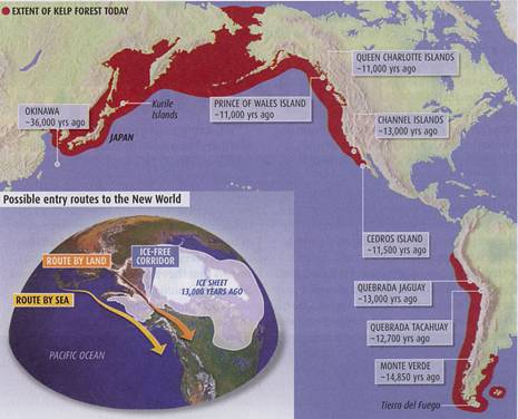 the
Bering Straights land bridge some 13½ years ago and down into America. But the journey sounds pretty horrific. And it will have required them to adapt to a
succession of different eco systems. Why
would they bother unless they were pretty desperate?
the
Bering Straights land bridge some 13½ years ago and down into America. But the journey sounds pretty horrific. And it will have required them to adapt to a
succession of different eco systems. Why
would they bother unless they were pretty desperate?
And now further evidence is beginning to shoot holes
in the theory anyway.
An article in New
Scientist (11 August 07) suggests a new theory, and one much more in
keeping with what we have been saying.
But first we should remind ourselves of a theory, also
aired in New Scientist, about first
primitive humans that left Africa. They
could easily have been fairly primitive Australopithecines
“just following the grass”. And there’s
evidence that it could have been some 3 million years ago. This goes against
traditional scientific thinking. But
animals do it. Why not primitive humans?
Now it’s suggested that modern humans followed the
coast around from Asia to America “just following the kelp”. This map comes from the N.S. article. The red zone shows where kelp was thought to have
been at the time. Which route would you choose?
Kelp is a wonderful habitat for all sorts of
nutritious marine life, so it’s an excellent food source for anybody with a
boat. There would have been no need to
conquer these hostile ecosystems.
Conditions would have been much the same all they way round. However, whenever the migrants found some
good habitat a bit further inland, then no doubt some would settle and put down
roots there.
Evidence is emerging of colonisation much earlier than
previously thought, around 20 thousand years ago I think. I’m a bit confused. The land bridge would have been even more horrendous
any earlier than 12-12 thousand years ago.
Did folk have boats long enough ago? There’s no direct evidence. The sea level was a good 100 metres (300
feet) lower than it is today – or possibly 50 metres (150 ft). Authorities seem to differ. We may eventually get some evidence
though. Underwater archaeologists are
beginning to contemplate diving to such depths.
But we can say that humans had been colonising remote islands as long as
36 thousand years ago. To reach Okinawa,
for example, would have needed a sea voyage of 75 kilometres. So the answer has to be yes.
What sort of boats?
Well it was probably too cold for reeds.
As we’ve seen, the South Seas were probably first colonised by bamboo
rafts. Once folk had got the idea for
boats, they would certainly have found something.
Colonising the Pacific
I’ve read many reports attempting to suss out when the
various more distant Pacific islands were colonised, by whom and from
where. To reach them would have needed
serious navigating skills, on top of the ability to handle boats. It’s not surprising that the colonisation
appears to have started only about 4 thousand years ago. I’ve not seen anything definite, so we’ll
concentrate on how these ‘primitive’ peoples might have achieved the
feats of navigation required.
When the Europeans began exploring the Pacific, they
were amazed to find our ‘primitive’ peoples inhabiting islands huge distances
from any mainland. Of course, said they,
they could not possibly have sailed there in their primitive canoes with no
instruments. So the Europeans invented
all sorts of fantastic scenarios, including the sinking of a great continent
leaving only the peaks above water. Total rubbish all of it. But even today there are pre-historians who
can’t bear the thought that these folk were actually as smart as we are.
However this changed in the late 1700s, when Captain
Cook studied the Tahitian canoes and navigation methods, and judged them to be
perfectly capable of long voyages. He
was told that if the sailors wanted to go East, they waited for the westerlies
to come. To come back, they waited for
easterly trade winds to return.
Many years ago, I read how the Polynesians navigated.
I can’t guarantee to have it exactly right.
But it went something like this.
First, we have to note that many Pacific islands
(presumably the taller ones) are most of the time adorned with a cloud
cap. And this cap can be seen even when
the island itself is way below the horizon.
Second, the Pacific skies are normally more or less
cloud-free, particularly (I’m guessing here) at night. This means that the seafarers were able to
get extremely familiar with the stars.
And they would sail towards ‘the rising’ of this star, or ‘the setting’
of that one. It must have taken
considerable skill and experience to judge this when the star was still high in
the sky. But clearly they were able to
do it.
I would guess also that the Pacific ocean currents are
generally a good deal weaker than they are in the North Atlantic, where the
Vikings did their momentous voyages. The
Atlantic currents regularly sweep you miles away from where you thought you
were. And if you can’t account for this
then you are in trouble. The Vikings
needed a gadget for estimating their latitude (their North/South-ness as it
were) to help keep them on course. I’ve not read that the Polynesians had such a gadget. But it was very simple,
and eminently inventable by any seafarer with the need. On the other hand, if you really know your
stars, then maybe you don’t need an instrument.
Sail and Egyptian boats
Now we come to Europe and the Mediterranean
waters. The earliest evidence of
seafaring on the Med. Dates to only 12-13 ky ago. Ánd even that is indirect. It comes from signs of human occupation on
Cyprus and the Greek island of Milos. Why
should this be? The science
article has an answer. The Mediterranean waters are almost barren of fish. There is little tidal movement, and the
temperature gradient of the water traps nutrients on the sea bad, far too deep
for sunlight to penetrate, and allow photosynthetic bugs to thrive. So why would they venture on to that
dangerous sea?
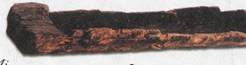 According
the the article, the oldest actual boats so far found are at most 10 ky
old. They are hollowed out logs like
this one, and have been found in the
According
the the article, the oldest actual boats so far found are at most 10 ky
old. They are hollowed out logs like
this one, and have been found in the
However civilisations first appeared around the 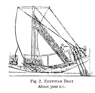 world
like a reed boat with a mast and sail.
We’ll probably never know what it was actually made from. This picture is of a slightly later boat,
around 5,000 years ago. Like the
following one, it comes from Romola & R.C. Anderson’s ‘The Sailing Ship’.
world
like a reed boat with a mast and sail.
We’ll probably never know what it was actually made from. This picture is of a slightly later boat,
around 5,000 years ago. Like the
following one, it comes from Romola & R.C. Anderson’s ‘The Sailing Ship’.
Like all early depictions, it shows the mast up in the
bow, out of the way. This is an
excellent arrangement in many ways. It
leaves plenty of room for cargo. And it
allows the ‘backstays’ to be taken to the stern at a good angle, to minimise
the stress on both rope and hull.
This was important.
The Egyptians didn’t have access to the big mature trees that we
northerners are used to. They had to
make their boats from smaller bits fastened together. Their hulls were inevitably much weaker and
floppier than they would have liked.
Indeed the next picture shows clearly a stout rope, running over
trestles from stem to stern. Other
pictures show this same rope twisted up bar taut.
There’s one small snag to having all the sail area up
in the bow. You can only sail down
wind. If the wind is in the north, then
lets say that you can sail anywhere between SSE and SSW. If you want to go anywhere else then you have
to get the oars out. And having all
those oarsmen on board is a heavy overhead.
Another feature of these early boats is that only the
middle part was actually in the water.
This is not clever from a sailing point of view. For both speed and stability, you need the
maximum ‘waterline length’ possible. On
the other hand it’s handy for loading and unloading from a beach. And the weakness of the hull may have given them
no choice.
Square rig
But by around 3½ thousand years ago, the mast had
moved to the middle. They won’t have
done this for fun. They must have
discovered that it gives  them
much more freedom over where they can go under sail.
them
much more freedom over where they can go under sail.
In doing so, the Egyptians invented what we would now
call Square rig. Think men o’ war like
HMS Victory or clipper ships like Cutty Sark (I’m British so I’m afraid I’ll
tend to give British examples.)
One is often asked why a sailing boat can’t sail into
the eye of the wind. In truth that’s the
wrong question. The correct question to
ask is “how is it possible to con the wind into pushing you against itself at
all?”
The answer is “with low cunning and
aerodynamics”. You have to fashion the
sail into a kind of poor man’s aircraft wing.
The closer to the wind you want to sail, the better your ‘wing’
approximation has to be. In particular,
the ‘leading edge’ of the sail has to be straight, and able to point straight
into the wind. This enables the sail to
coax the airflow gently round a curve, as in the coloured picture below. It is this finesse that provides the ‘lift’
on both an aircraft wing and a sail.
The square rig is a down-wind rig. A modern square-rigged boat is also quite
good ‘across the wind’. It can sail at
good speed, with the wind in the north, anywhere from east, through south to
west. The fact that the Egyptians kept
their large crew of oarsmen perhaps suggests that they remained somewhat
limited in this regard.
The ultimate development of the square rig comes with
the Men o’ War and the Clipper Ships. A
three-masted square rigger can cram on huge amounts of canvas. A clipper in particular can carry a full
cargo downwind at ridiculous speeds. But
upwind the rig is very poor indeed. The
clippers often preferred to go on round the world rather than face a return
voyage of headwinds.
One can think of many ways to stiffen and straighten
the leading edge of a square sail. But
they must all have proved impractical because none of them ever caught on.
The fore-and-aft rig
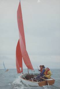 Instead,
the Egyptians invented the fore-and-aft rig.
This picture of a modern example
was taken by Colin Waters. It
shows a fore-and-aft rig doing what it does best – sailing close to the
wind. The burgee at the top of the mast
will have been fluttering more or less parallel with the leading edge of the
sail. Downwind, the fore-and-aft rig is
nowhere near as good as the square rig.
Instead,
the Egyptians invented the fore-and-aft rig.
This picture of a modern example
was taken by Colin Waters. It
shows a fore-and-aft rig doing what it does best – sailing close to the
wind. The burgee at the top of the mast
will have been fluttering more or less parallel with the leading edge of the
sail. Downwind, the fore-and-aft rig is
nowhere near as good as the square rig.
The earliest type of fore-and-aft rig to appear is the
lateen sail. It was probably invented by
the Nile sailors some 1500 years ago (around 500 AD). And of course it’s still to be seen there
today. We’ve all seen pictures of
it. It’s a natural progression from the
square sail, but it’s still not very good for upwind work.
The best upwind effect is obtained by attaching the
leading edge of your sail to a bar-taut near-vertical wire, as in a modern
yacht’s jib. The mainsail loses a
certain amount of thrust due to its being attached to the thicker mast. When the northern sailors caught on to the
benefits of the fore-and-aft rig, they gradually improved it to approach closer
and closer to this ideal.
The fore-and-aft is a go-anywhere rig. If well set up, it should be able to sail to
within about 45° of the wind. This means
that it can progress upwind in 90° zigzags.
So it can make reasonable progress in whatever direction the skipper
wishes.
Eventually, when steam reached the sea, sail declined
in importance. Today sailing is a purely
leisure activity.
© C B Pease, December 07