A TIMELINE FOR THE
PLANET click for Home Page
The Great Flood
The Great Flood was a world-wide disaster.
When I was young (in
Black Sea world-wide floods Doggerland
Now however we know exactly what happened.
At the end of the ice age, around 10 thousand years ago, unbelievable
amounts of ice started to melt from the northern continents. The melting ice lifted sea levels by around 120
metres or 400 feet. And vast amounts of
inhabited land were inundated.
The Black Sea
One explanation of the Flood myth says that it occurred at the
There may be an answer to this.
But I’ve now seen three theories,
and they’re all different. Something
catastrophic certainly seems to have happened at the Black Sea. But exactly what, and even how long ago it
might have been, is still under debate.
World-wide floods
But in fact you don’t need a catastrophic
folk-being-drowned-in-their-beds event to explain a flood myth. What certainly happened to coastal peoples
all around the world was quite traumatic enough.
World-wide, the process was slow to begin with. The flooding doesn’t seem to have become
serious until some 9 thousand years ago. It will never have been
catastrophic. But in the flatter places,
all round the world, vast areas will have been snatched away during a single
lifetime. A similar amount will have
been taken during the next lifetime. And
the next, and the next, for hundreds (thousands?) of years. This will have been more than enough to
generate a Great Flood legend.
Could a ‘flood legend’ have lived for thousands of years? Well it seems that non-literate societies
often have a caste of trained story tellers, whose brief is to pass on myths
and legends accurately. So it probably
could. More recently we’ve heard of
tsunami legends which saved the lives of the folk who knew it, when the tsunami
struck again.
One place that was hard hit was the ‘Fertile Crescent’ of
Mesopotamia. We discuss this elsewhere, because it’s where agriculture is
supposed to have been invented. But I’ve
not seem much about how much land was actually flooded – or where.
Doggerland
By contrast, the North sea, between Britain and Denmark has already been
studied in remarkable detail. Our first
map comes from a Channel 4 Time Team programme.
It’s not very clear. But it 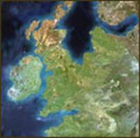 shows that, just 10
thousand years ago, the southern North Sea was a great plain that stretched all
the way from Britain to Denmark. Earlier
than that, I’ve seen maps showing much more dry land still.
shows that, just 10
thousand years ago, the southern North Sea was a great plain that stretched all
the way from Britain to Denmark. Earlier
than that, I’ve seen maps showing much more dry land still.
The territory has been called Doggerland, from the large area of
sandbanks off Britain’s east coast – the Dogger Bank – which is now all that’s
left of it.
The second map comes from the BBC website and covers the same time
period. 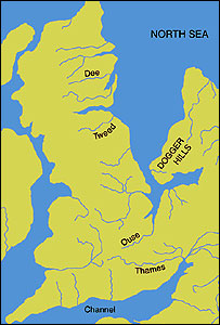 It only depicts
western Doggerland, but it gives a better indication of the amount of detail
that can already be put in. The two maps
have slightly different coastlines, but that’s paleo-geography for you. Inevitably, there’s quite a bit of guesswork
involved.
It only depicts
western Doggerland, but it gives a better indication of the amount of detail
that can already be put in. The two maps
have slightly different coastlines, but that’s paleo-geography for you. Inevitably, there’s quite a bit of guesswork
involved.
Huge amounts of archaeological material have been dredged up from the
North Sea bed by fishermen. There are
dinosaur bones, elephant bones, hippo bones, and many more.
During the depths of the ice age, the area was just tundra, like
everywhere else around. But being lower,
Doggerland warmed up a bit sooner than the higher ground. And the slowly rising waters kept the land
moist, producing grasslands, forests, marshes and lakes.
Doggerland became an excellent place to live, and people flocked
in. The archaeologists are currently
trying to pin down places where folk were actually living. Then they hope to find out much more about
how they lived. But underwater
archaeology is a slow, dangerous and painstaking business. So we shouldn’t hold our breaths.
But it only remained like that for a couple of thousand years. By 8 thousand years ago, Britain was an
island. And by 6 thousand years ago, the
last vestige disappeared beneath the waves.
© C B Pease, December 07